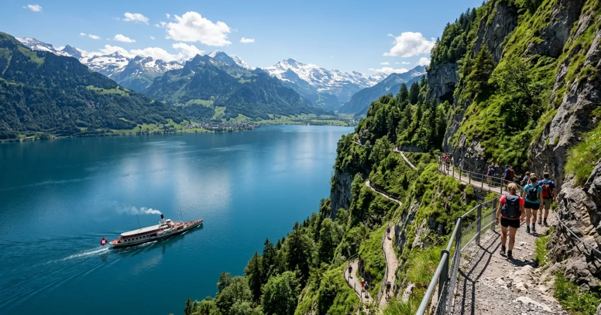
The Swiss Path is more than just a hiking trail; it is a physical representation of Switzerland's democratic history. Inaugurated in 1991, the trail's 35 kilometers are meticulously divided among the 26 Swiss cantons. The journey begins at the Rütli meadow, the legendary birthplace of the Swiss Confederation in 1291. From there, the path winds through dense forests, climbs up to panoramic terraces like Seelisberg, and descends to the Mediterranean-like climate of Bauen.
Logistics along the Swiss Path are seamlessly integrated with Switzerland's world-class public transport network. Hikers can effortlessly combine walking with scenic rides on historic paddle steamers or modern trains. The trail is dotted with designated picnic areas, barbecue fire pits, and informative plaques detailing the history and geography of the region. Whether you are seeking a rigorous multi-day trek or a leisurely afternoon walk with family, the Swiss Path offers an accessible and deeply rewarding way to experience the heart of Switzerland.
Reasons to Visit
- Experience the historical birthplace of Switzerland at the Rütli meadow.
- Enjoy unparalleled, panoramic views of Lake Uri and the surrounding alpine peaks.
- Benefit from a highly customizable itinerary thanks to excellent boat and train connections.
- Walk through diverse landscapes, including rock tunnels, lakeside promenades, and mountain forests.
- Engage in a sustainable, slow-travel experience that promotes health and nature appreciation.
Things to Avoid
- Avoid hiking during heavy rain or thunderstorms, as cliffside paths can become slippery and dangerous.
- Do not rely solely on the last boat or train of the day; always check the timetable to ensure you don't get stranded.
- Avoid buying bottled water; bring a reusable bottle to fill up at the free, clean public fountains.
- Do not stray from the marked trails, especially in protected nature reserves and steep areas.
Local Transportation Tips
Public transport is the lifeblood of the Swiss Path experience. The Lake Lucerne Navigation Company (SGV) operates regular boat services connecting key trailheads like Rütli, Bauen, Flüelen, and Brunnen. The Swiss Federal Railways (SBB) also runs frequent trains along the eastern shore, making it incredibly easy to skip sections or return to your base. Purchasing a regional pass, such as the Tell-Pass, offers unlimited travel on boats, trains, and buses in the area, providing excellent value for active explorers.
Travel Etiquette
- Always greet fellow hikers with a friendly 'Grüezi' when passing on the trail.
- Respect private property and agricultural land; close any gates you open behind you.
- Pack out all your trash; do not leave litter on the trails or at picnic sites.
- Keep noise levels down to respect the tranquility of nature and local wildlife.
Recommended Age Group
The Swiss Path is a versatile destination that caters to a wide range of ages and abilities, thanks to its segmented nature and excellent transport links.
- Babies (0-2 years): Neutral. While some lakeside sections (like Flüelen to Sisikon) are flat and paved enough for sturdy strollers, many parts involve steep stairs and uneven terrain, requiring a baby carrier.
- Kids (3-12 years): Recommended. Children will love the boat rides, the rock tunnels near Bauen, and the numerous picnic spots with fire pits.
- Teens (13-19 years): Recommended. The trail offers highly 'Instagrammable' scenery and enough physical challenge to keep teenagers engaged and active.
- Adults (20-64 years): Recommended. Perfect for adults seeking a mix of physical activity, historical exploration, and stunning natural beauty.
- Seniors (65+ years): Recommended. The ability to hike short, flat sections and use boats or trains for the rest makes it highly accessible for active seniors.
Accessibility Level: Medium
- The section between Bauen and Flüelen is largely flat, paved, and suitable for wheelchair users and those with limited mobility.
- Most boats operating on Lake Lucerne are wheelchair accessible, allowing everyone to enjoy the scenic transfers.
- Train stations at Flüelen and Brunnen offer step-free access and accessible restroom facilities.
- Steeper sections, such as the climb from Rütli to Seelisberg, are not suitable for wheelchairs or those with severe mobility impairments.
Did You Know?
The length of each canton's section on the Swiss Path was calculated based on its population in 1991, equating to exactly 5 millimeters per inhabitant. This means the heavily populated canton of Zurich has the longest stretch, while the small canton of Appenzell Innerrhoden has one of the shortest.
Cool Statistics
- Total length of the Swiss Path: 35 kilometers (22 miles).
- Number of Swiss cantons represented along the route: 26.
- Year the trail was officially opened: 1991.
- Highest point on the trail: Seelisberg, at approximately 850 meters above sea level.






Buy a compatible power adapter for your trip