Low – budget‑friendly basics
Medium – moderate mid‑range costs
High – pricey lodging, dining & transport
Disclosure: This site contains affiliate links. We may earn a commission if you make a purchase, at no extra cost to you.
Low – budget‑friendly basics
Medium – moderate mid‑range costs
High – pricey lodging, dining & transport
5 shields = Excellent – very low crime or conflict.
4 shields = Safe – low risk, routine care.
3 shields = Relatively safe – use normal street smarts.
2 shields = Use caution – higher crime or periodic unrest.
1 shields = Avoid – active conflict or extreme danger.
Scores are derived from multi-year peace, homicide and security indices blended into a single 1-to-5 scale.
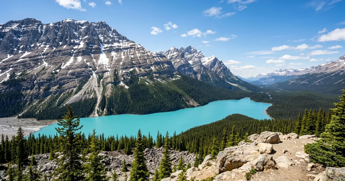
Peyto Lake stands among the most celebrated alpine panoramas in North America, attracting sightseers, photographers, and road-trippers traveling Alberta's iconic Icefields Parkway. The lake is situated approximately 44 kilometers north of Lake Louise and approximately 100 kilometers north of the town of Banff. Visitors typically combine an excursion to the lake with broader itineraries covering Jasper and Banff National Parks, utilizing personal vehicles, rental campervans, or guided bus tours. The optimal window for viewing the lake's vivid turquoise hue spans from late June through early October, once seasonal winter snows clear and glacial silt infuses the alpine basin. High-elevation conditions mean weather shifts rapidly, requiring layered thermal clothing even during midsummer. The site features dedicated parking areas for cars and motorcoaches, alongside a designated drop-off point that provides barrier-free access to the lower lookout for travelers with physical mobility permits.
Peyto Lake ranks among the most photographed natural wonders in the Canadian Rockies. Located in the northern reaches of Banff National Park, this classic moraine-dammed lake owes its existence to the retreating Peyto Glacier. Each spring and summer, roaring glacial streams wash millions of tons of glacial flour into the basin. When viewed from Bow Summit—the highest point on the Icefields Parkway at 2,088 meters above sea level—the lake strikingly resembles the outline of a howling wolf or fox.
In recent years, Parks Canada completed an extensive multi-million dollar rehabilitation project at the Bow Summit site. The project improved trail grades, constructed expansive viewing decks with safety railings, tripled visitor parking capacity, and built accessible pathways that permit travelers of all physical capabilities to witness the panoramic vista without navigating hazardous gravel slopes.
Personal vehicle or rental car is the standard method of transport to Peyto Lake, located off Highway 93 North approximately 40 minutes north of Lake Louise. Commercial hop-on-hop-off shuttles, guided sightseeing coaches, and private tour operators based in Banff, Lake Louise, and Jasper also service the Bow Summit parking lot throughout the summer season. There is no municipal public transit directly servicing the Icefields Parkway.
Peyto Lake accommodates travelers of virtually all ages thanks to thoughtful paved infrastructure and short walking distances.
Peyto Lake was named in honor of Ebenezer William 'Bill' Peyto, a legendary 19th-century mountain guide, fur trapper, and early park warden whose eccentric frontier persona helped pioneer early exploration across the Canadian Rockies.

Peyto Lake experiences sharp alpine seasonal shifts, with the most comfortable access occurring between late June and September when trails are ice-free.
| Month | °C | °F |
|---|---|---|
| Jan | -9 | 16 |
| Feb | -11 | 12 |
| Mar | -5 | 23 |
| Apr | -1 | 30 |
| May | 6 | 43 |
| Jun | 10 | 50 |
| Jul | 15 | 59 |
| Aug | 15 | 59 |
| Sep | 10 | 50 |
| Oct | 1 | 34 |
| Nov | -7 | 19 |
| Dec | -11 | 12 |
Remember to check the weather forecast a few days before the trip and before heading to the airport.
5 shields = Excellent – very low crime or conflict.
4 shields = Safe – low risk, routine care.
3 shields = Relatively safe – use normal street smarts.
2 shields = Use caution – higher crime or periodic unrest.
1 shields = Avoid – active conflict or extreme danger.
Scores are derived from multi-year peace, homicide and security indices blended into a single 1-to-5 scale.
The rating is based on multi-year peace, crime, and security indices. Before you go, always verify current conditions through official government travel advisories.
No internet needed • Includes local translations • Free for TravelingWiz readers

Low – budget‑friendly basics
Medium – moderate mid‑range costs
High – pricey lodging, dining & transport
Per person, per day – pocket cash for small purchases.
Full daily spend estimation (accommodation, food, transportation, attractions).
Travel Style | Canadian Dollar (CAD) | ≈ USD ($) |
|---|---|---|
Budget | 260 | 184 |
Mid-range | 480 | 340 |
Comfort | 1060 | 750 |
The Prices, Daily costs, and calculator results are estimates for planning purposes only. Actual costs may vary based on season, booking timing, personal spending habits, and currency fluctuations. TravelingWiz cannot be held responsible for discrepancies between these estimates and your final trip expenses.
Choose a ready-made itinerary, plan your own trip, and keep TravelingWiz by your side while you travel.
Get the TravelingWiz app →
Discover cooking classes, tastings and local food tours
Logistics shouldn’t be the focus of your trip—the experience should. I’ve hand-vetted these essential partners to ensure your arrival, stay, and exploration are as smooth as an Athenian breeze.

Compare accommodation options and choose a stay that suits your plans and budget.
Connect with local guides for personalized help planning and exploring.
The “Engineer’s” rule: always have a backup. Secure your trip with a plan that covers every “what if” and unexpected change.
Don’t let paperwork slow you down. Get expert assistance with your application to ensure all your entry documents are in order.
Check out our related articles and blog posts to learn even more about the destination.
Share with your friends and family