Disclosure: This site contains affiliate links. We may earn a commission if you make a purchase, at no extra cost to you.

>
>
>
Annapurna Region

Annapurna Region

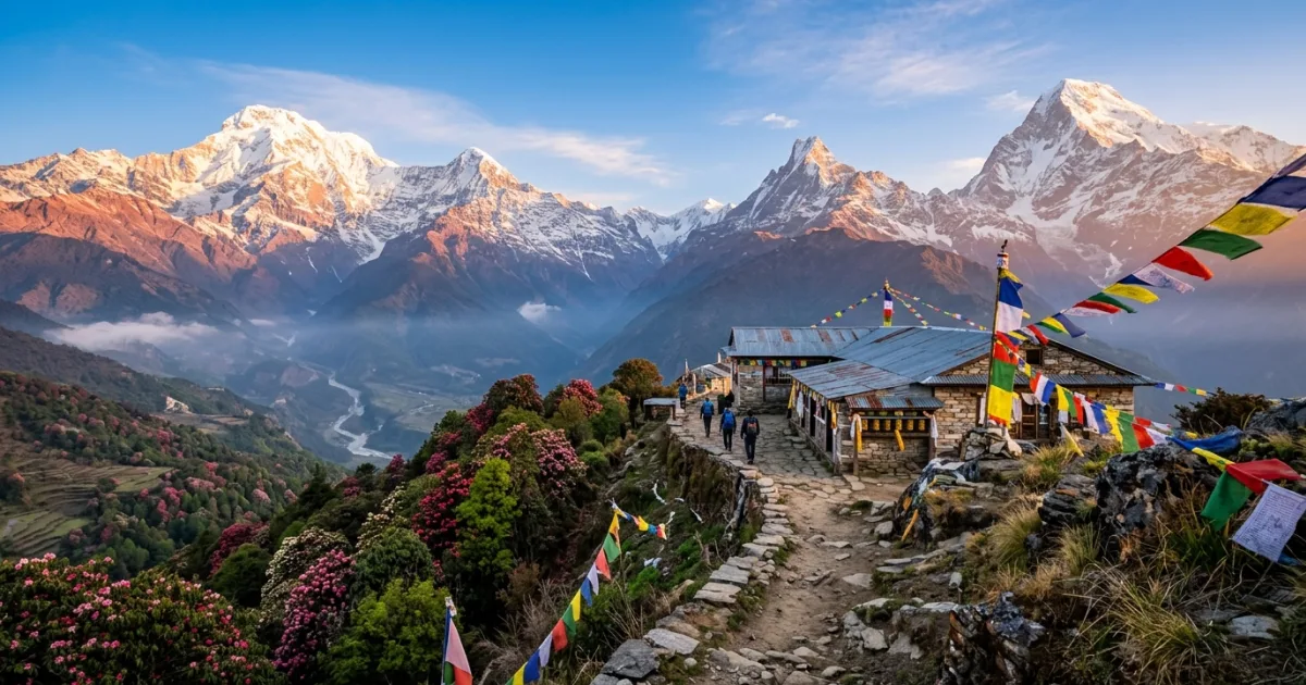
Snow-capped peaks of the Annapurna mountain range with Buddhist prayer flags in Nepal

Annapurna Region Overview & Key Highlights

The Annapurna Region of north-central Nepal is one of the world's most renowned trekking destinations, anchored by the Annapurna Massif and its sixteen peaks towering above 6,000 meters. Traversing this diverse geographical corridor reveals subtropical rhododendron forests, terraced paddy fields, arid trans-Himalayan valleys, and glacial amphitheaters. High mountain trails connect isolated Gurung, Magar, and Tibetan-influenced settlements, providing travelers with authentic glimpses into indigenous Himalayan customs. Outdoor enthusiasts journey along classic routes such as the Annapurna Circuit, the Annapurna Sanctuary to Annapurna Base Camp, and shorter panoramas like Ghorepani Poon Hill. The Annapurna Conservation Area Project (ACAP) safeguards the region's rich biodiversity, including rare species like snow leopards and blue sheep. Whether navigating the grueling Thorong La Pass at 5,416 meters or soaking in natural hot springs beside roaring alpine rivers, visitors encounter a balanced wilderness experience complemented by an established teahouse hospitality network.

Annapurna Region Travel Guide: Logistics & In-Depth Tips

The Annapurna Region encompasses over 7,600 square kilometers within the Annapurna Conservation Area of north-central Nepal. Stretching from lush subtropical lowlands at 800 meters to the summit of Annapurna I at 8,091 meters—the world's tenth-highest peak—the territory features unprecedented geographical diversity. The southern slopes capture heavy monsoon rains, fostering dense bamboo and rhododendron forests, while the northern trans-Himalayan plateau borders the Tibetan Plateau in a dramatic, windswept rain-shadow zone.

For centuries, these mountain passes served as active trade corridors linking salt merchants from Tibet with lowland agricultural villages. Today, the area operates as a premier global trekking destination while retaining its spiritual core. Ancient Buddhist gompas, chortens draped in wind-whipped prayer flags, and sacred Hindu pilgrimage sites like Muktinath coexist along trail routes, making a journey through the Annapurnas as culturally transformative as it is physically challenging.

Reasons to Visit

  • Spectacular close-up vistas of world-famous summits including Annapurna I, Machapuchare (Fishtail), and Dhaulagiri.
  • Rich cultural immersion within historic Gurung, Magar, Thakali, and Tibetan-heritage mountain settlements.
  • Extensive network of accessible teahouse routes catering to both novice day-hikers and seasoned high-altitude mountaineers.
  • Unmatched ecological transitions ranging from terraced valleys and mossy forests to arid high-altitude alpine deserts.
  • Natural geothermal hot springs along river canyons like Tatopani and Jhinu Danda.

Things to Avoid

  • Do not ascend too rapidly without built-in acclimatization rest days, as altitude sickness can become life-threatening quickly.
  • Avoid drinking untreated tap or stream water without filtering or chemical purification.
  • Do not photograph monks, temple interiors, or local villagers without first asking for polite permission.
  • Never walk on the cliffside when pack animals approach; always step safely to the mountain wall side.
  • Avoid using single-use plastic bottles, which create severe environmental waste burdens in isolated mountain communities.

Local Transportation Tips

Travel throughout the Annapurna interior is conducted primarily on foot along designated mountain footpaths. Transit to trailheads originates from Pokhara via local public buses, shared jeeps, or private four-wheel-drive hires navigating rugged mountain roads to hubs such as Besisahar, Nayapul, or Jomsom. Regular domestic flights also connect Pokhara Airport with Jomsom Airport, offering rapid access to the Mustang valley, weather permitting.

Travel Etiquette

  • Always walk around Buddhist stupas, mani stones, and chortens in a clockwise direction.
  • Dress modestly on the trail and cover shoulders and knees when visiting temples, monasteries, and village homes.
  • Remove shoes before stepping into any sacred shrine, monastery sanctuary, or private family room.
  • Use your right hand or both hands when giving or receiving food, money, or personal gifts.

Recommended Age Group

Trekking in the Annapurna Region involves rugged terrain, altitude extremes, and basic living amenities that require specific fitness and maturity levels.

  • Babies (0-2 years): Not Recommended. High altitudes, cold weather extremes, and remote medical isolation make high-altitude trekking unsafe for infants.
  • Kids (3-12 years): Neutral. Lower altitude village walks around Pokhara or Dhampus are feasible, but major multi-day circuits over high passes are unadvisable.
  • Teens (13-19 years): Recommended. Active teenagers with good cardiovascular fitness and outdoor enthusiasm will thrive on trails like Poon Hill and Annapurna Base Camp.
  • Adults (20-64 years): Recommended. Ideal demographic for tackling the physical challenges and cultural richness of multi-week mountain expeditions.
  • Seniors (65+ years): Neutral. Feasible for active seniors with strong hiking experience and clean medical clearance, particularly on gentler lower-elevation trails with flexible itineraries.

Accessibility Level: Medium

  • Trail terrain is rocky, steep, and completely devoid of wheelchair-accessible infrastructure outside select modern hotel facilities in Pokhara.
  • High mountain suspension bridges, narrow dirt paths, and stone staircases require sustained physical agility and balance.
  • Helicopter sightseeing flights from Pokhara directly into the Annapurna Sanctuary provide scenic access for travelers with mobility limitations.

Did You Know?

Machapuchare, the distinctive double-peaked mountain dominating the skyline above Pokhara and the Annapurna Sanctuary, is considered a sacred dwelling place of Lord Shiva and remains strictly closed to mountaineering, leaving its summit untrodden by humans.

Cool Statistics

  • 5,416 meters: The elevation of Thorong La Pass, the highest point of the Annapurna Circuit.
  • 8,091 meters: Summit elevation of Annapurna I, the 10th highest mountain on Earth.
  • 7,629 square kilometers: Total protected land area within the Annapurna Conservation Area.
  • Over 1,200 species: Flowing plants, mammals, and birds recorded within the diverse conservation zone.


Address:

Annapurna Conservation Area, Nepal

Find Nearby Accommodations

Basic Info

address icon

COUNTRY & Region

Nepal,
Asia

ACCESSIBILITY LEVEL​

Medium
Currency icon

LOCAL CURRENCY​

Nepalese Rupee (NPR)
Price level icon
Low
Safety Level icon

SAFETY LEVEL

Duration icon

Recommended Duration

• More than a week

Electricity

electricity icon

Electricity

220-240V, 
50Hz
Plug Socket icon

Plug Type

• Type C (Round pin)
• Type D (Three round pins in a triangular pattern)
• Type M (Three round pins, larger)
Plug types
Click To View Plug Types
Annapurna Region is part of our
Coolcation collection

Things To Do In Annapurna Region

Total: 1

Activities To Do In Annapurna Region

Best Time To Visit Annapurna Region

Trekking conditions depend strictly on Himalayan weather seasons, with autumn and spring offering the optimal balance of visibility and safety.

  • October to November (Autumn): Peak trekking season characterized by dry trails, stable high-pressure systems, and exceptionally clear mountain panoramas.
  • March to May (Spring): Second prime window featuring warmer daytime temperatures and vibrant blooming rhododendron forests at mid-elevations.
  • June to August (Monsoon): Heavy rain, leech-infested lower trails, landslide hazards, and obscured peaks; Upper Mustang remains an arid rain-shadow exception.
  • December to February (Winter): Bitter cold and heavy snow that frequently closes high passes like Thorong La, though lower elevation treks remain accessible.

Average Temperatures Per Month

Remember to check the weather forecast a few days before the trip and before heading to the airport.

Safety Level icon

Safety Level

Altitude sickness (Acute Mountain Sickness) poses the primary health hazard; ascend no more than 300 to 500 meters per day above 3,000 meters and maintain hydration. Landslides can occur on unpaved mountain roads during weather shifts, so check route reports daily. Always yield mountain trails to donkey and yak caravans by stepping toward the mountainside rather than the cliff edge. Carry comprehensive travel insurance that explicitly covers emergency helicopter evacuation up to 6,000 meters.

The rating is based on multi-year peace, crime, and security indices. Before you go, always verify current conditions through official government travel advisories.

Emergency Numbers

Police: 100
Ambulance: 102

No internet needed • Includes local translations • Free for TravelingWiz readers

Spoken Languages

Nepali, Gurung, Magar, Tibetan dialects, and conversational English in teahouses.

Learn The Language

  • Namaste – Hello / Greetings (with palms together)
  • Dhanyabaad – Thank you
  • Kasto chha? – How are you?
  • Sanchai chha – I am fine
  • Paani – Water
  • Kati parchha? – How much does this cost?
  • Bistari jaanus – Walk slowly / Go slowly
  • Pheri bhetaula – See you again
Travel Booking Partner - TravelingWiz

Trip Cost & Budgeting for Annapurna Region, 2026

Everything you need to know about money while traveling
Is Annapurna Region expensive for tourists in 2026? No, the Annapurna Region remains very affordable for international travelers. Based on our Human Verified prices, expect to pay around 300 NPR for a coffee, 650 NPR for a local beer, and 800 NPR for a standard main meal at mountain teahouses or local restaurants. Daily costs increase slightly at higher altitudes. Use the data table below to calculate your specific daily budget based on your travel style.
Currency icon

LOCAL CURRENCY​:

Nepalese Rupee (NPR)
Price level icon
Low
Credit cards are accepted in Pokhara, but physical cash is mandatory once you enter the trekking trail.

Per person, per day – pocket cash for small purchases.

Local: 520
Nepalese Rupee (NPR)
≈ 3 USD

Full daily spend estimation (accommodation, food, transportation, attractions).

Travel Style
Nepalese Rupee (NPR)
≈ USD ($)
Budget
2850
18
Mid-range
5200
34
Comfort
11450
74

The Prices, Daily costs, and calculator results are estimates for planning purposes only. Actual costs may vary based on season, booking timing, personal spending habits, and currency fluctuations. TravelingWiz cannot be held responsible for discrepancies between these estimates and your final trip expenses.

  • Order dal bhat at teahouses for nutritious meals that include free refills on rice and lentils.
  • Fill reusable water bottles using purification tablets instead of purchasing expensive single-use plastic bottles on trail.
  • Buy essential trekking gear and supplies in Pokhara or Kathmandu rather than paying premium prices in high-altitude villages.
  • Obtain your ACAP permit directly in Pokhara or Kathmandu beforehand to avoid inflated emergency registration fees at checkpoints.

Pre-Order Tickets

Avoid disappointment when tickets sell out — and skip the long lines by booking online in advance. You’ll often save up to 20% too.
Save up to 20%

Travel Discounts & Coupons

Save on hotels, attractions, transport, and gear — find verified discounts for smarter travel spending.
Verified Coupons

What To Pack

  • Sturdy, broken-in waterproof trekking boots with ankle support
  • Layered moisture-wicking thermal base layers and fleece mid-layers
  • Windproof and waterproof outer shell jacket with hood
  • Down jacket rated for sub-zero temperatures
  • High-grade UV protection sunglasses and broad-spectrum sunscreen
  • Water purification tablets or UV sterilizer system
  • High-altitude first aid kit including blister treatment and Diamox
  • Trekking poles with shock absorption
  • Comfortable sub-zero rated sleeping bag for high-altitude teahouses
We couldn't find tips for Annapurna Region.
If you got any, please share

Recommended Itineraries for Traveling to Annapurna Region

We couldn't find itineraries for Annapurna Region.
you can contact us for custom trip plan

Food & Drink Highlights

Local Food Overview

Cuisine across the Annapurna Region is deeply tied to sustaining high-energy mountain travel. The cornerstone of every trail menu is Dal Bhat, an aromatic combination of lentil soup, boiled white rice, seasonal vegetable curry (tarkari), and pungent fermented mustard greens or pickles (achar). At higher altitudes influenced by Tibetan culinary culture, meals transition into hearty noodle soups like thukpa, hand-rolled momo dumplings, roasted barley flour (tsampa), and warming yak butter tea. Trailside bakeries in towns like Manang and Marpha also serve fresh apple pies made from local mountain orchards.
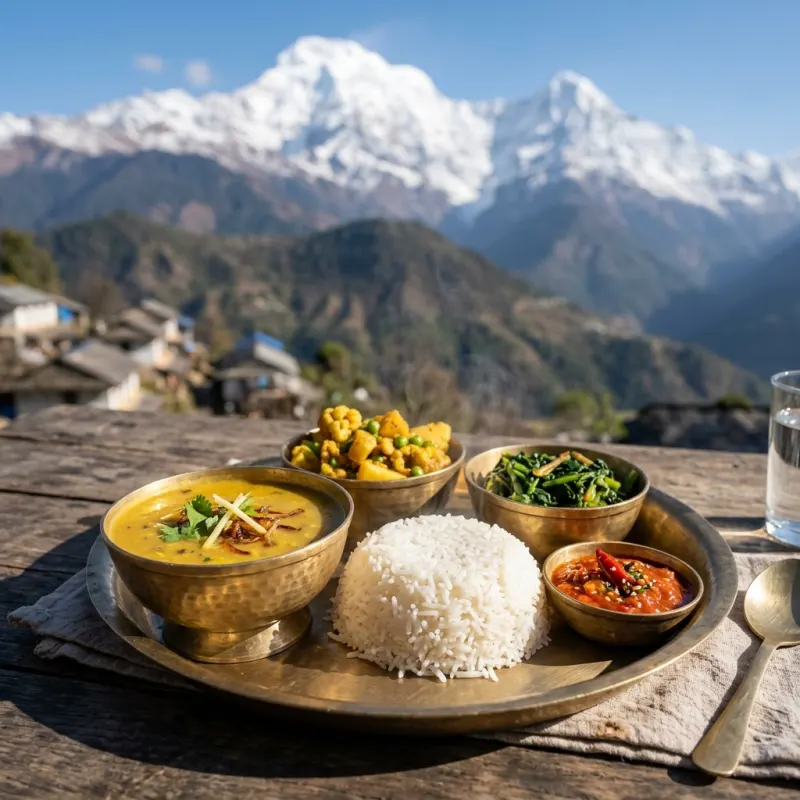
Authentic Nepalese Dal Bhat served on a traditional brass platter in the Annapurna mountains

Must Try Dish

Himalayan Dal Bhat - A nutritious platter of spiced lentil broth poured over steamed white rice, served alongside seasonal curried vegetables, wild mountain greens, and house-made fermented chili pickle. It remains the fuel of the Himalayas, offered with unlimited complimentary refills in every mountain teahouse.
Food Experiences Title Icon

Food
Experiences

Discover cooking classes, tastings and local food tours

No food experience found
Maya, the human travel expert at TravelingWiz, offering curated, non-AI expertise

Maya’s Final Checklist for Annapurna Region

Logistics shouldn’t be the focus of your trip—the experience should. I’ve hand-vetted these essential partners to ensure your arrival, stay, and exploration are as smooth as an Athenian breeze.

Where to Stay

From boutique hotels to local apartments—compare thousands of options and find the perfect stay in the best neighborhood.

Air Travel

Getting there should be seamless. Compare the best routes and prices across top airlines to start your journey on the right note.

Local Guides

Connect with experts who know the destination best. Get personalized advice and insider tips to help you plan your perfect trip.

Travel Protection

The “Engineer’s” rule: always have a backup. Secure your trip with a plan that covers every “what if” and unexpected change.

Car Rentals

Explore at your own pace with total freedom. Compare reliable rental options and find the right vehicle for your adventure.

Visa Services

Don’t let paperwork slow you down. Get expert assistance with your application to ensure all your entry documents are in order.

FAQs

All trekkers must obtain an Annapurna Conservation Area Project (ACAP) entry permit and a Trekkers’ Information Management System (TIMS) card prior to entering the region, both available through the Nepal Tourism Board offices in Pokhara or Kathmandu.
The Annapurna Circuit is classified as moderately strenuous to challenging, requiring good physical endurance for 5 to 7 hours of daily walking over 12 to 18 days, with the most demanding challenge being the crossing of Thorong La Pass at 5,416 meters.
Under current Nepal Tourism Board regulations, foreign trekkers are required to hire a licensed trekking guide or porter-guide when trekking in conservation areas, enhancing trail safety and supporting local mountain employment.
Accommodation consists of family-run teahouses offering simple twin-bed rooms with foam mattresses and communal squat or Western toilets. Hot gas or solar showers and device charging are typically available for a small supplemental fee.

Your Insights Matter

TravelingWiz grows through the stories of our community. If you’ve recently explored ,Annapurna Region share your tips and stories to help us perfect our guides for the next traveler.

Related Articles

Check out our related articles and blog posts to learn even more about the destination.

No related articles found

Don’t Travel Alone

Share with your friends and family

Where should we send your offline card?

We hate spam just as much as you do

newsletter_consent *